

Bucksnbears
Well-Known Member
This is my uncles property. He's about 2 miles from me and owns about 4/5 miles of continuous river bottom. He allowed me to put in a foodplot so 3 weeks ago, I mowed,sprayed,fertilized,tilled about a 1/2 acre spot. Planted pumpkins 2 weeks ago (100 plants).
They are coming up nicely so early this morning, I brought buckets to cover them and went down the rows and sprayed what weeds was coming with gly. Took the buckets off and watered each with 1/2 gallon of water. We are real dry here. 25% of the plot is pumpkins and the rest I will put in brassicas late July.
Next was to hang 2 ladderstand, cut shooting lanes, pre dig 2_ 7"x 24" deep holes (one in front of each stand) for where I will put in rub post in mid September. ( Aspen).
Also hung 2 grape vine licking branches and planted 6 Mammoth Brand Sunflowers for rub post
One of my yearly funnest projects.
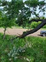
All this was farmed (corn/ beans) untill about 10 years ago. But with the major flooding we get some years, it has washed out the " blue dotted line" so bad, can no longer get back there with equipment so he has just let it go. It is now a 100 acres of some of the best wildlife habitat imaginable. It's all 3_5' of tall grass and MANY 1000's of small ash,boxelder,basswood,burr Oak and elm trees growing.
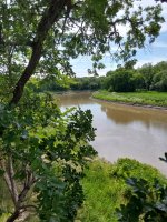
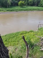
In the pictures, that's N.D. across the river. From the one stand, it's A LONG WAY DOWN to the river and super steep.
Blue circle is a pond.
Small black dots are stand sites.
Red is the Red River separateing Mn from N.D.
silver square is the foodplot. I should add, the spot were the foodplot is is the highest ground and Indians had a camp there years ago.
Anyway here are some pics. Hope you enjoy.
in the 4th and 9th pics, you can see the stands.


They are coming up nicely so early this morning, I brought buckets to cover them and went down the rows and sprayed what weeds was coming with gly. Took the buckets off and watered each with 1/2 gallon of water. We are real dry here. 25% of the plot is pumpkins and the rest I will put in brassicas late July.
Next was to hang 2 ladderstand, cut shooting lanes, pre dig 2_ 7"x 24" deep holes (one in front of each stand) for where I will put in rub post in mid September. ( Aspen).
Also hung 2 grape vine licking branches and planted 6 Mammoth Brand Sunflowers for rub post
One of my yearly funnest projects.
All this was farmed (corn/ beans) untill about 10 years ago. But with the major flooding we get some years, it has washed out the " blue dotted line" so bad, can no longer get back there with equipment so he has just let it go. It is now a 100 acres of some of the best wildlife habitat imaginable. It's all 3_5' of tall grass and MANY 1000's of small ash,boxelder,basswood,burr Oak and elm trees growing.
In the pictures, that's N.D. across the river. From the one stand, it's A LONG WAY DOWN to the river and super steep.
Blue circle is a pond.
Small black dots are stand sites.
Red is the Red River separateing Mn from N.D.
silver square is the foodplot. I should add, the spot were the foodplot is is the highest ground and Indians had a camp there years ago.
Anyway here are some pics. Hope you enjoy.
in the 4th and 9th pics, you can see the stands.
Attachments
Last edited: